High-Resolution Site Characterization
Real-time subsurface clarity
Continuous lithologic, hydraulic, and contaminant data logged 20 times per foot, delivered to your team as field work becomes decision-ready maps, logs, and models.
Our toolkit
Which tool to use?
Each HRSC logging tool supports specific investigation objectives, contaminant types, and hydrogeologic questions. Not sure which one you need? We'll help you choose.
| Tool | Sensors | Target compounds | Best use case | |
|---|---|---|---|---|
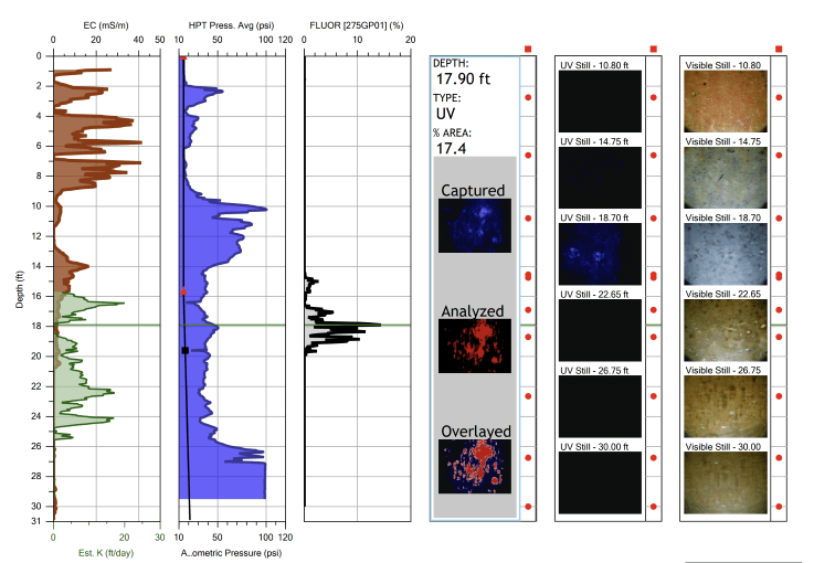
OIHPTAvailable in UV (275 nm), Green (520 nm), and UV-Range configurationsMost popular | Fluorescence Camera (UV or Green)HPT PressureElectrical Conductivity | NAPL — petroleum fuels, creosote, coal tar, heavy oils. Camera wavelength selected based on target compounds. | Gas stations, fuel terminals, manufactured gas plants, pipeline releases, wood treating facilities | Details → |
MIHPTAlso available as Low Level MIHPT (~10× sensitivity increase) for trace-level detection | PID (photoionization)FID (flame ionization)XSD (halogen-specific)HPT PressureElectrical Conductivity | Dissolved and vapor-phase VOCs — petroleum hydrocarbons, chlorinated solvents, mixed plumes | Dissolved plume delineation, vertical contaminant profiling, petroleum and chlorinated solvent sites | Details → |
Groundwater Profiler | Discrete Interval SamplingHPT PressureElectrical Conductivity | All dissolved-phase contaminants (depth-discrete samples for laboratory analysis) | Plume vertical profiling, regulatory sampling, lab-confirmed concentrations | Details → |
HPT | HPT PressureElectrical Conductivity | N/A — measures formation properties, not contaminants | Hydrogeologic characterization, injection well design, barrier assessments | Details → |
What is HRSC?
High-Resolution Site Characterization
High-Resolution Site Characterization (HRSC) is an approach to environmental site investigation that uses scale-appropriate measurement and sample density to define contaminant distributions and the geologic and hydrogeologic framework that controls contaminant fate and transport. The term was formalized by the U.S. EPA through its Triad methodology and is now considered the standard of practice for complex contaminated sites.
HRSC logging tools measure continuously as they advance through the subsurface, recording lithologic, contaminant, and hydraulic data 20 times per foot. In one push, you get vertical and horizontal delineation — identifying preferential pathways, contaminant mobility, and clean-to-impacted transitions. With thousands of data points per log from multiple data streams, we are able to develop highly accurate conceptual site models — rapidly, in a single site visit.
The foundation of HRSC is the recognition that subsurface heterogeneity occurs at scales much finer than traditional sampling can resolve. Thin clay lenses, perched NAPL zones, and preferential flow pathways all exist at the centimeter-to-meter scale. Traditional 2–5 foot sampling intervals routinely miss these features. HRSC addresses this by combining real-time sensor data — contaminant detection, formation properties, and depth-discrete groundwater sampling — into a continuous profile that reveals where contamination exists, why it exists there, and how it is likely to move.
HRSC vs. traditional methods
Subsurface heterogeneities that control contaminant transport occur at the centimeter to meter scale. HRSC measures at that scale. Traditional methods do not.
Traditional
Grab samples every 2–5 feet
HRSC
Continuous data 20 times per foot
40–100× more data density per borehole
Traditional
Lab results in days to weeks
HRSC
Real-time results during the investigation
Field decisions happen while the rig is still on-site
Traditional
Data gaps between sample intervals
HRSC
Continuous vertical profile — no gaps
Thin clay lenses, perched NAPL, and preferential pathways are captured
Traditional
Multiple mobilizations to refine CSM
HRSC
More complete characterization from a single mobilization
Fewer site visits, faster path to remedy selection
Traditional
One-dimensional well data
HRSC
Full 3D contaminant and lithologic models
Spatial relationships between sources, pathways, and receptors become visible
EPA 2023 Industry Study
High Resolution Site Characterization at Petroleum UST Release Sites
In 2023, the EPA published a comprehensive study on HRSC adoption at petroleum underground storage tank (UST) release sites. The findings confirmed what HRSC practitioners have seen in the field:
- HRSC saves an average of 9–19% in total project costs compared to traditional methods
- HRSC reduces remediation timelines by an average of 3.3 years on a typical 10-year project
- For catastrophic releases and stalled remediation, HRSC always saves costs
- The added data from HRSC makes the investigation worthwhile even when cost impacts are neutral
The study concluded that expanding HRSC use at petroleum UST sites represents a significant opportunity to reduce remediation costs and timelines while improving environmental outcomes.
Real-time delivery
Your data, delivered as it's collected.
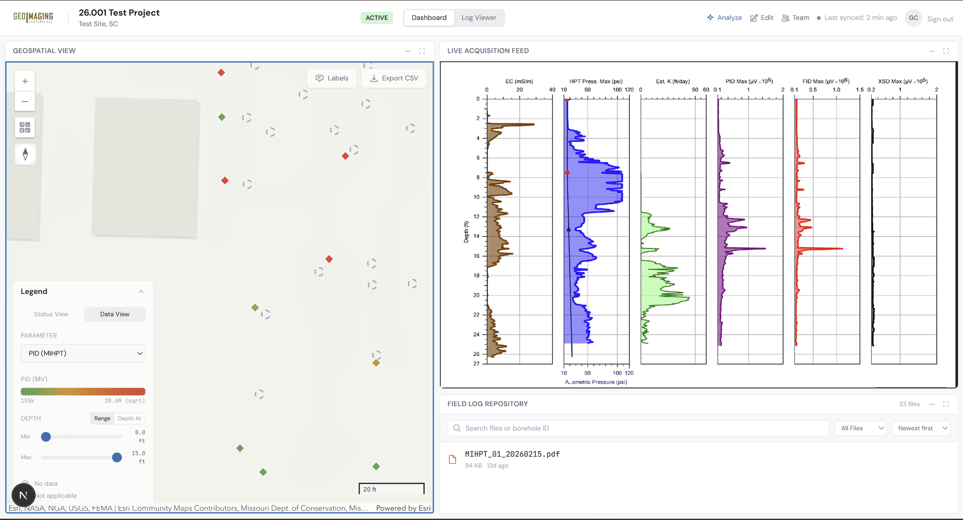
Every GeoImaging project includes a secure, browser-based dashboard. As our HRSC logging tools log data in the field, it can be streamed directly to your team — interactive log viewers, borehole maps, live video, and file delivery.
No installs. No waiting for email reports. No static PDFs. Your investigation data is live, accessible from any browser, 24/7.
Explore the dashboardFinal deliverables
From raw data to 3D site models.
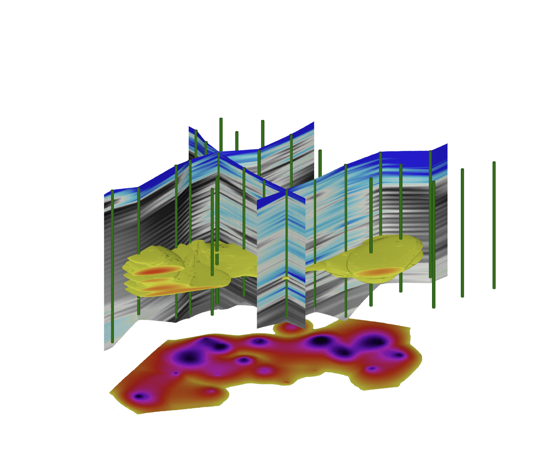
We transform HRSC sensor data into interactive 3D contamination models, lithologic cross-sections, and plan-view maps. Built with C Tech Development Corporation's Earth Volumetric Studio (EVS).
Full deliverables include 2D footprint maps, cross-sections, and depth-slice plans — complete spatial context from surface to source.
Explore our modelsReady to investigate?
Tell us about your site and we'll recommend the optimal HRSC logging tool for your investigation objectives.